


CGX Energy Inc. which has a Joint Operating Agreement (“JOA”) with Frontera Energy Guyana Corporation (“FEGC”), recently informed the market that it had contracted PGS Geophysical AS (“PGS”) to provide acquisition and processing of a full broadband marine 3D seismic survey over a northern segment of the Corentyne Block located offshore Guyana.
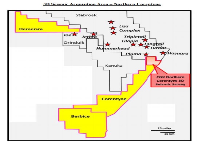
The seismic acquisition was completed on November 2, 2019, and produced seismic data covering approximately 582 km2 of the northern portion of the Corentyne Block. Guyana Standard understands that PGS completed Time (PreStack Time Migration) and Depth (PreStack Depth Migration) processing of these data on June 5, 2020.
Further to this, CRI disclosed that it has also completed a preliminary evaluation of the recently processed 3D seismic data, and has identified two potentially highly prospective large channel sand reservoir complexes. The company said that these channel complexes are interpreted to contain multiple high potential leads located in the northern region of the Corentyne Block which is located in proximity to the Stabroek Block offshore Guyana and Block 58 offshore Suriname.
CGX was keen to note that the Pluma and Haimara discoveries in the Stabroek Block are located approximately two and eight miles, respectively from the border of the northern region of the Corentyne Block and the Maka Central, Kwakwasi-1 and Sapakara West discoveries in Block 58 are located approximately seven, 15 and 20 miles, respectively from the border of the northern region of the Corentyne Block.
CGX said that the leads mapped in the Northern Corentyne Block are interpreted to be situated at the same geological horizons as the nearby significant discoveries already proven in the Stabroek Block and Block 58. Importantly, the Northern Corentyne leads are interpreted to share the same proven hydrocarbon generating basin and intervals in which the current discoveries are located.
CGX stated that these leads are primarily stratigraphic traps composed of sandstone accumulations and deemed to be analogous to many of the discoveries already proven to be successful in the Guyana basin.
With respect to the Northern Corentyne leads, CGX noted that these are in the process of being high-graded and have been mapped within the Upper Cretaceous, Santonian, and Miocene intervals and are currently undergoing further analysis in order to prioritize and rank the best prospect to be drilled. This news agency understands that the leads are located in water depths ranging from approximately 500 to 3,600 feet and are estimated to be at a drilling depth of between approximately 11,000 to 21,700 feet.
Further to this, CGX informed the market that the current high-graded lead identified in the northern region of the Corentyne Block has been named Kawa, after the iconic Kawa Mountain which overlooks the village of Paramakatoi in the Pakaraima Mountains of Guyana. The company disclosed that it is a Santonian level, stratigraphic trap and as previously mentioned is interpreted to be analogous to the discoveries immediately to the east on Block 58 in Suriname. Additional leads are being evaluated by the company.
Further to the foregoing, CRI told its shareholders that it has recently contracted Baker Hughes to provide a pore pressure analysis of the Kawa prospect which will be completed in August 2020.
On the Demerara block, Guyana Standard understands that CRI will begin re-processing the existing seismic data at the end of the third quarter, this year in order to mature previously mapped leads into prospects ready for drilling.


