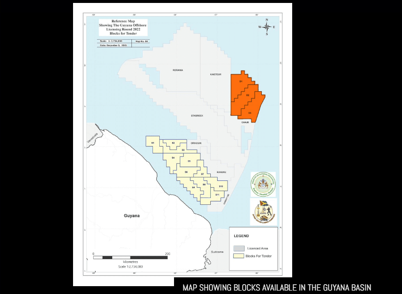
Accessing updated evaluations of Guyana’s deepwater blocks have been made easier as Petroleum Geo-Services (PGS), a leading global provider of subsurface data, has created a new high-quality depth dataset for the nation. It did so by leveraging its comprehensive experience across the Guyana basin and applying recent imaging technology advancements. This announcement was made by PGS in a report issued this week.
The data released is some 4460 km of rejuvenated 2D GeoStreamer depth data supporting the evaluation of Blocks D1, D2, and D3.

It said, ” Quantitative Interpretation products have also been generated to aid the identification of amplitude anomalies that indicate potential hydrocarbon presence.” For greater context, quantitative seismic interpretation usually demonstrates how rock physics can be applied to predict reservoir parameters, such as lithologies and pore fluids, from seismically derived attributes.
In the report, the company, whose seismic service offerings help oil companies find oil and gas reserves offshore, noted that the new data presents an excellent opportunity for exploration and production (E&P) companies interested in Guyana’s first deepwater licensing round to evaluate the potential of the highly prospective area.
It also boasted of applying state-of-the-art imaging technology to the underlying broadband GeoStreamer acquisition data to provide new insights into the offered acreage. That data provides accurate structural imaging while also preserving amplitude fidelity, allowing it to be used for both regional screening and detailed prospect evaluation using amplitude analysis techniques, including inversion for rock properties.
The company further revealed that all data is available for licensing from PGS in agreement with Guyana’s Ministry of Natural Resources. Both time and depth datasets are now available to review. Companies can access the Ministry’s data room to view the legacy pre-stack time migration (PSTM) data, while contact with PGS directly is needed to arrange a data show for the new pre-stack depth migration PSDM data.
Elaine Mattos, Senior Vice President of Sales & Services at PGS, has noted that her company is pleased to support Guyana in its first deepwater licensing round. According to Mattos, “Our 2D programme is the only available multi-client data over the deepwater blocks and gives companies the ability to assess the area ahead of the license round.
With its comprehensive experience and state-of-the-art technology, PGS’ said its seismic data have the potential to offer valuable insights to global E&P companies and help unlock the potential of Guyana’s deepwater blocks.
It is noteworthy that in 2021, the Norwegian offshore seismic acquisition specialist was awarded a 4D acquisition contract by ExxonMobil for work offshore Guyana. A Titan class vessel was scheduled to mobilize for the project in fourth quarter of 2021 and acquisition was scheduled for completion in the first quarter of 2022.


